

Zion National Park, situated in southwestern Utah, USA, encompasses 229 square miles of diverse landscapes, including deep canyons, towering sandstone cliffs, and narrow slot canyons. Key attractions within the park include The Narrows, Angels Landing, Observation Point, and Emerald Pools, offering visitors a range of hiking opportunities suited to different skill levels. The lesser-visited Kolob Canyons section features stunning red rock formations and scenic trails. Zion National Park is home to over 900 plant species, as well as various wildlife, such as mule deer, bighorn sheep, and over 200 bird species, making it a popular destination for nature enthusiasts.
Official website:
https://www.nps.gov/zion/
https://www.nps.gov/zion/ (trail descriptions)
Google map 4.8/5
The Best Places to Visit in the Zion National Park
The Narrows (hike)
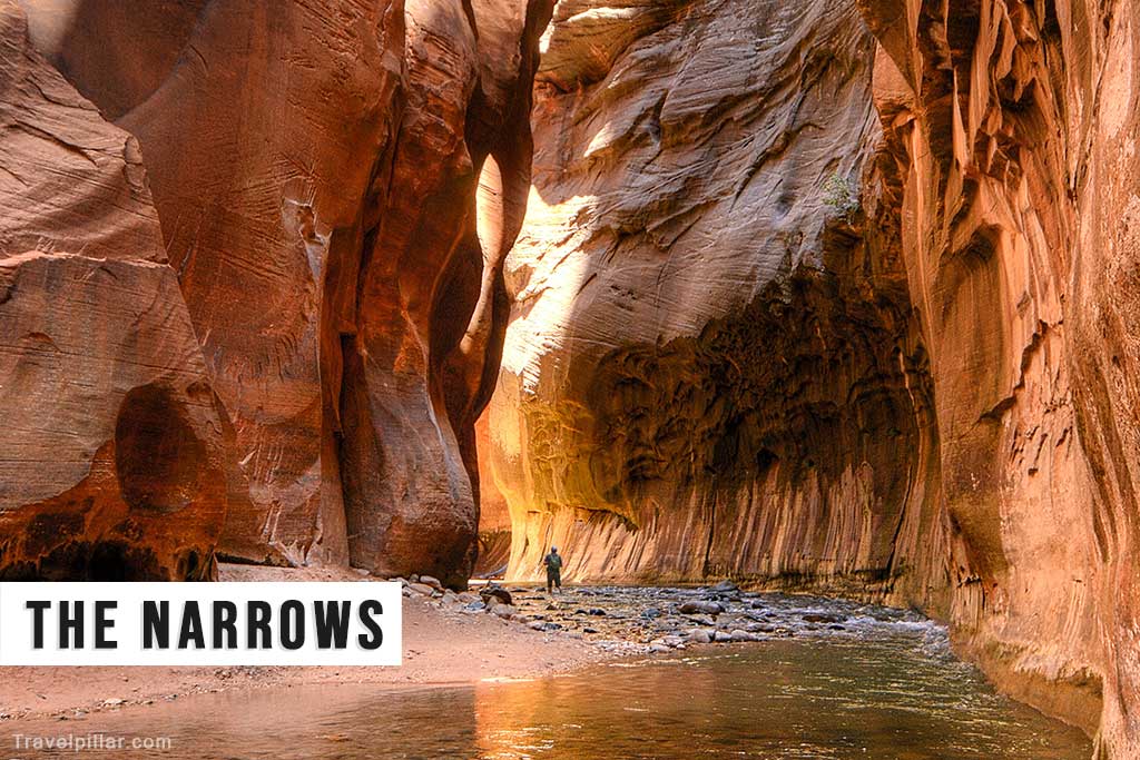
This iconic hike (9.4 miles round trip) takes you through the narrowest section of Zion Canyon, where the Virgin River has carved a slot canyon with sandstone walls reaching up to 1,000 feet high. The bottom-up day hike starts at the Temple of Sinawava and can be customized to various distances. For a more adventurous experience, the top-down, 16-mile overnight hike requires a permit and traverses the entire length of the Narrows. Always check conditions with park ranger before starting.
Website: https://www.nps.gov/zion/ * read this when planning the hike
Google map The Narrows 4.9/5
Google map Riverside Walk Trailhead at Temple Of Sinawava (start of hike) 4.8/5
Google map Temple Of Sinawava Parking Lot (Shuttle bus only)
Google map Zion Canyon Visitor Center (shuttle bus service) 4.7/5
Angels Landing (hike)

This exhilarating 5.4-mile round-trip hike leads to a breathtaking viewpoint overlooking Zion Canyon. The trail features steep switchbacks, known as Walter’s Wiggles, and a narrow ridge with chains for support. Due to its challenging nature and exposure to heights, Angels Landing is recommended for experienced hikers without a fear of heights.
Google map Angels Landing mountain peak
Google map Walter’s Wiggles 4.9/5
Google map Start of the Angels Landing Trail 4.9/5
Google map Grotto Parking Lot
Observation Point (Hike on the East Rim Trail from Weeping Rock)
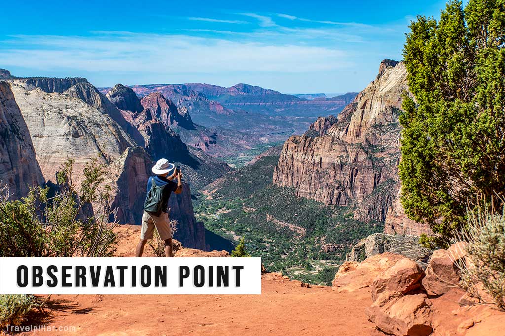
This 8-mile round-trip hike takes you to an overlook perched 2,148 feet above the canyon floor, providing panoramic views of Zion Canyon, Angels Landing, and the surrounding sandstone cliffs. The strenuous trail involves a series of switchbacks and passes through Echo Canyon, known for its unique rock formations.
Google map Observation Point, mountain peak and scenic viewpoint 4.9/5
Google map Weeping Rock Trailhead 4.8/5
Google map Echo Canyon Passage 4.8/5
Canyon Overlook Trail

This 1-mile round-trip trail offers stunning views of Pine Creek Canyon and lower Zion Canyon, including notable landmarks like the West Temple and the Tower of the Virgin. The trail is relatively short and easy, making it suitable for most visitors.
Google map Pine Creek Canyon Overlook 4.9/5
Google map Canyon Overlook Trailhead & Parking Lot
Riverside Walk (short, easy version of the Narrows hike)

Riverside Walk is a tranquil and family-friendly trail along the Virgin River. This paved path winds through lush vegetation, revealing stunning views of the towering canyon walls. As the gateway to the Narrows, Riverside Walk offers a gentle introduction to Zion’s slot canyons and provides a refreshing escape into the park’s natural beauty.
Google map Riverside Walk Trailhead at Temple Of Sinawava (start of hike) 4.8/5
Google map Temple of Sinawava Parking Lot (Shuttle bus only)
Google map Zion Canyon Visitor Center (shuttle bus service) 4.7/5
Kolob Canyons

Situated in the less crowded northwestern part of the park, Kolob Canyons boasts dramatic red rock formations and scenic trails. The 5-mile scenic drive provides numerous overlooks, while hiking trails like the Taylor Creek Trail and the Kolob Arch Trail lead to beautiful canyons, creeks, and the world’s second-largest natural arch.
Website: https://www.nps.gov/zion/
Google map Kolob Canyons 4.7/5
Google map Kolob Canyons Visitor Center 4.5/5
Google map Kolob Canyons Viewpoint & Picnic Area
Google map Taylor Creek Trailhead 4.8/5
Checkerboard Mesa

This striking sandstone formation features a unique grid-like pattern of intersecting cracks, resembling a checkerboard. Visible from the Zion-Mount Carmel Highway near the park’s east entrance, Checkerboard Mesa is an easily accessible and impressive geological feature.
Google map Checkerboard Mesa peak 4.6/5
Google map Checkerboard Mesa View Area 4.8/5
Zion Canyon Scenic Drive
Zion Canyon Scenic Drive is the main access route through the heart of Zion National Park. Spanning 6 miles, this paved road is dotted with pullouts offering stunning views of towering sandstone cliffs, lush valleys, and the Virgin River. Ideal for both driving and shuttle exploration, it provides a comprehensive introduction to Zion’s iconic landscapes.
Note: From March through late November, access to the Zion Canyon Scenic Drive is by shuttle bus only. Private vehicles are allowed to access the Scenic Drive only when the Shuttle System is not in operation. Check website for details.
Google map southern end (Canyon Junction Bridge)
Google map Big Bend Viewpoint 4.8/5
Google map Temple Of Sinawava 4.8/5
Canyon Junction Bridge
Canyon Junction Bridge spans the Virgin River, offering a picturesque vantage point of the canyon’s majestic scenery. This iconic bridge is a popular spot for capturing the classic view of the Virgin River winding through towering sandstone cliffs. Providing access to various trails and viewpoints, it serves as a gateway to the park’s breathtaking landscapes.
Google map Canyon Junction Bridge 4.8/5
Pa’rus Trail
Pa’rus Trail is a scenic, paved pathway that meanders alongside the Virgin River. Stretching for 3.5 miles, the trail provides a leisurely stroll or bike ride with panoramic views of the canyon’s red rock formations. Offering accessibility and opportunities for wildlife viewing, Pa’rus Trail is a serene introduction to Zion’s natural wonders.
Google map Pa’rus Trailhead 4.7/5
Google map Zion Canyon Visitor Center & Parking 4.7/5
Google map Canyon Junction Bridge 4.8/5
Emerald Pools
Comprising three tiers—Lower, Middle, and Upper—Emerald Pools are a series of picturesque pools and waterfalls accessible via interconnected trails. The Lower Emerald Pool Trail is an easy, family-friendly hike, while the Middle and Upper Emerald Pool Trails involve moderate to strenuous sections with steep inclines and rocky terrain.
Google map Upper Emerald Pool 4.5/5
Google map Lower Emerald Pool 4.5/5
Google map Emerald Pools Trailhead 4.6/5
Google map Emerald Pools Trail Parking
Watchman Trail
The Watchman Trail is a moderately strenuous hike renowned for its captivating panoramic views. Ascending from the Visitor Center, the trail unveils vistas of the Watchman Peak and the Virgin River valley. Ideal for those seeking a rewarding half-day hike, the trail’s diverse landscapes showcase the park’s iconic red rock formations and offer a memorable adventure.
Google map Watchman Trail – Trailhead 4.8/5
Google map Zion Canyon Visitor Center & Parking 4.7/5