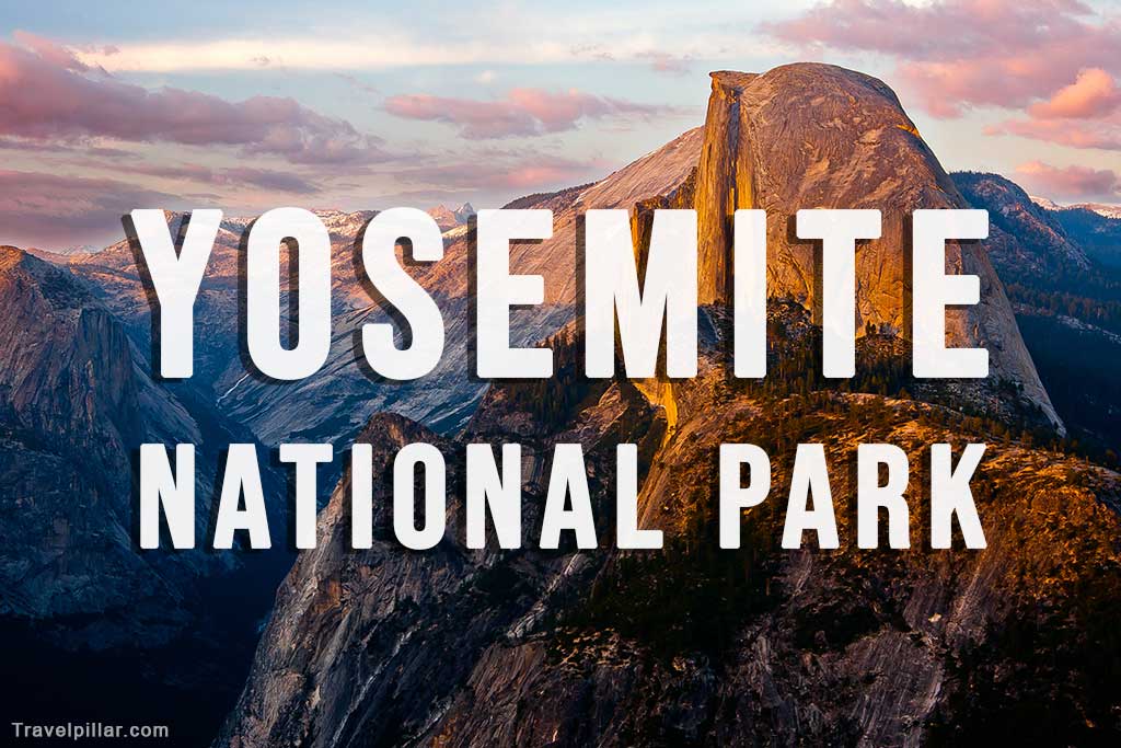
Yosemite National Park is a natural wonder located in California, USA. The park spans over 1,200 square miles and is home to an impressive array of natural features, including mountains, valleys, waterfalls, and forests.

The park is known for its iconic landmarks, such as Half Dome and El Capitan, which attract millions of visitors each year. Yosemite also offers a range of outdoor activities, such as hiking, rock climbing, and wildlife viewing. With over 800 miles of hiking trails, visitors can explore the park’s diverse terrain and witness its unique flora and fauna. Yosemite National Park is a must-see destination for anyone interested in the great outdoors and natural beauty.
Website: https://www.nps.gov/yose/index.htm
Google map 4.8/5
The Best Things to Do in Yosemite National Park
Glacier Point
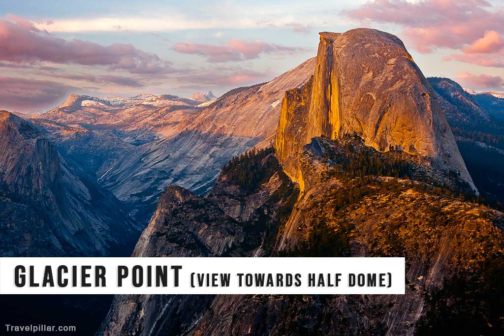
Glacier Point is one of the most popular viewpoints in Yosemite National Park. Located at an elevation of 7,214 feet, Glacier Point offers stunning panoramic views of the Yosemite Valley, including Half Dome, Yosemite Falls, and Yosemite’s high country. Visitors can reach Glacier Point by driving the Glacier Point Road or hiking the Four Mile Trail. The area is particularly stunning at sunrise or sunset when the sun casts a warm glow over the surrounding peaks. In addition to the incredible views, Glacier Point also offers easy access to hiking trails, picnic areas, and restrooms.
Incredible views of Half Dome, Yosemite Valley, Yosemite Upper & Lower Falls, Nevada & Vernall Falls
Google map 4.9/5
Google map (Glacier Point Trailhead) 4.8/5
Yosemite Falls
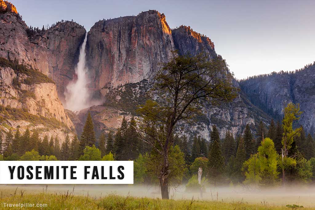
Yosemite Falls is one of the tallest waterfalls in North America, with a total height of 2,425 feet. The falls are made up of three separate sections: the Upper Falls, the Middle Cascades, and the Lower Falls. Visitors can view the falls from several locations throughout the park, including Yosemite Valley, Yosemite Village, and Yosemite Falls Trail. The easiest way to reach the base of the lower falls is via a short hike from the Yosemite Falls Trailhead. The falls are particularly impressive during the spring melt season, when the water flow is at its highest.
Google map 4.9/5
Google map (Yosemite Falls Trailhead) 4.9/5
Tunnel View
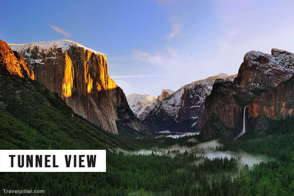
Tunnel View is an iconic overlook that provides one of the most breathtaking views of Yosemite Valley. Located along Wawona Road, Tunnel View offers panoramic views of El Capitan, Half Dome, Bridalveil Falls, and the valley floor. Visitors can access Tunnel View via a short drive from Yosemite Valley or by hiking the nearby trails. The area is particularly stunning at sunrise or sunset when the sun casts a warm glow over the surrounding peaks. In addition to the incredible views, Tunnel View also offers easy access to hiking trails, picnic areas, and restrooms.
Google map 4.9/5
El Capitan

El Capitan is a towering granite monolith that rises over 3,000 feet from the valley floor. The rock formation is a popular destination for rock climbers, who come from around the world to tackle its steep walls. Visitors can view El Capitan from several locations throughout the park, including El Capitan Meadow, Yosemite Valley, and El Capitan Picnic Area. The area is particularly stunning at sunrise or sunset when the sun casts a warm glow over the surrounding peaks. In addition to the incredible views, El Capitan also offers easy access to hiking trails, picnic areas, and restrooms.
Google map 4.8/5
Bridalveil Fall
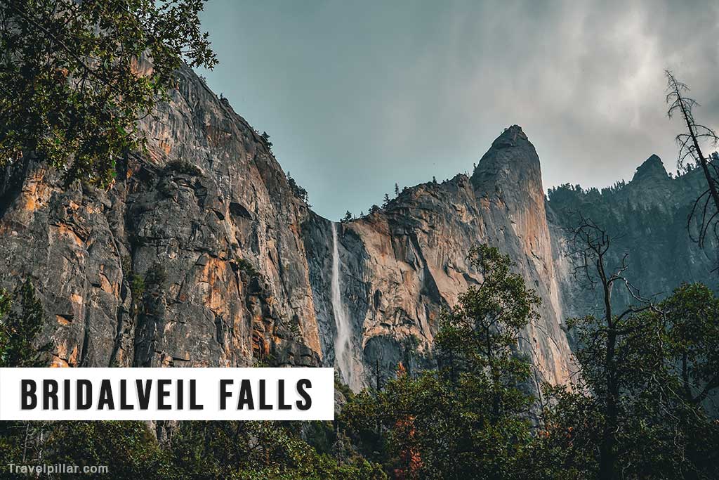
Bridalveil Fall is a stunning waterfall that drops 620 feet from a cliff into a picturesque valley. The waterfall is easily accessible by car and can be viewed from several lookout points throughout the park, including Bridalveil Fall Trail, Tunnel View, and Glacier Point. Visitors can also hike to the base of the falls via a short trail that begins near the Bridalveil Fall parking lot. The falls are particularly impressive during the spring melt season, when the water flow is at its highest. In addition to the incredible views, Bridalveil Fall also offers easy access to hiking trails, picnic areas, and restrooms.
Google map (viewpoint) 4.8/5
Half Dome
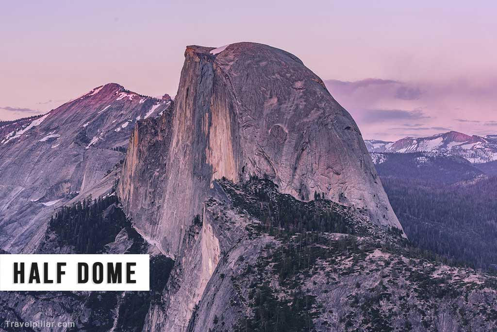
Half Dome is one of Yosemite’s most recognizable landmarks, with its distinctive shape and towering presence. The dome rises over 4,700 feet above the valley floor and is a popular destination for hikers and rock climbers. The most popular trail to Half Dome is the Half Dome Trail, which is a strenuous 16-mile round trip hike. The trail takes hikers through the scenic Yosemite Valley and provides stunning views of Yosemite’s high country. Visitors must obtain a permit to hike the Half Dome Trail, and the trail is closed during the winter months.
Google map 4.9/5
Yosemite Valley
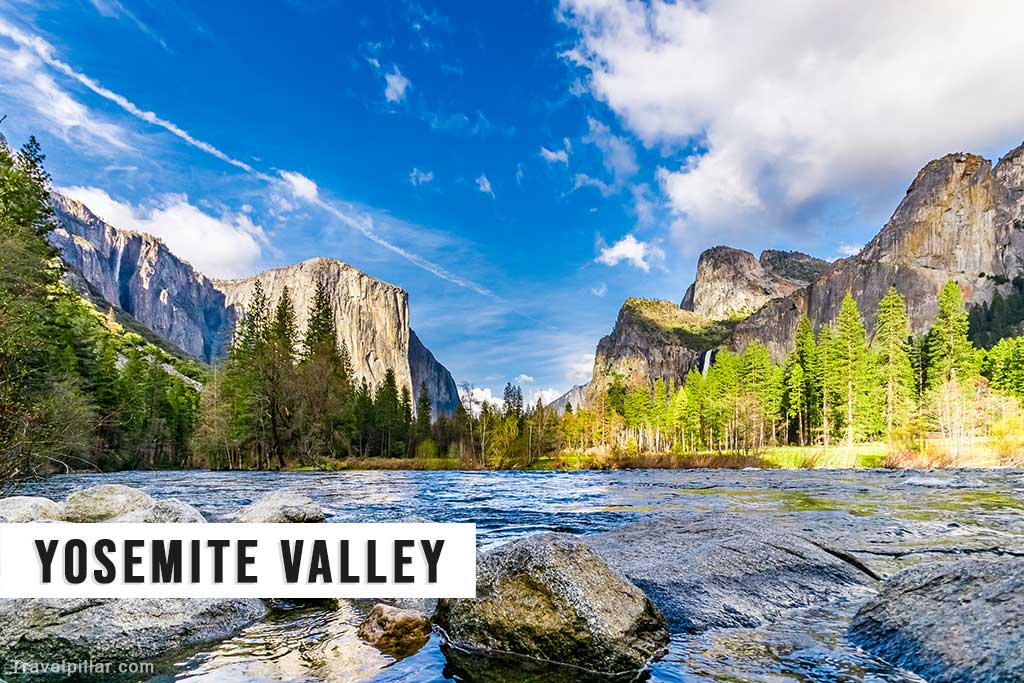
Yosemite Valley is the heart of Yosemite National Park and is home to some of the park’s most iconic landmarks, including El Capitan, Half Dome, and Yosemite Falls. The valley is a glacially carved, U-shaped canyon that is surrounded by towering granite cliffs and lush forests. Visitors can explore the valley via several hiking trails and bike paths, or by taking a scenic drive along the Valley Floor Loop. The valley is also home to several campgrounds, picnic areas, and visitor centers.
Google map (complete valley)
Google map (Yosemite Valley viewpoint) 4.9/5
Sentinel Dome
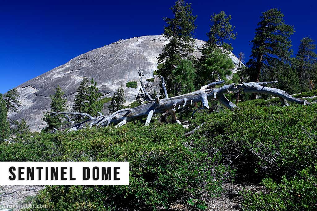
Sentinel Dome is a granite dome that rises over 8,100 feet above sea level and offers stunning panoramic views of Yosemite Valley and the surrounding peaks. The dome is accessible via a short 2.2-mile round trip hike, which takes visitors through a scenic forest and up to the top of the dome. Once at the top, visitors are rewarded with breathtaking views of Yosemite Valley, including Half Dome, Yosemite Falls, and El Capitan. Sentinel Dome is a popular destination for sunrise and sunset photography.
Google map 4.9/5
Taft Point
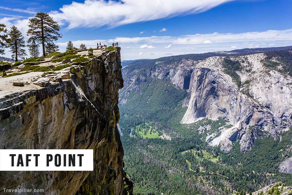
Taft Point is a stunning overlook that provides panoramic views of Yosemite Valley, including El Capitan, Half Dome, and Yosemite Falls. The point is accessible via a short hike from Glacier Point Road and is a popular spot for photography. Visitors can explore the surrounding area via several hiking trails, including the Fissures Trail, which takes hikers through a series of narrow cracks in the granite rock. Taft Point is also home to several picnic areas and restrooms.
Google map 4.9/5
Washburn Point
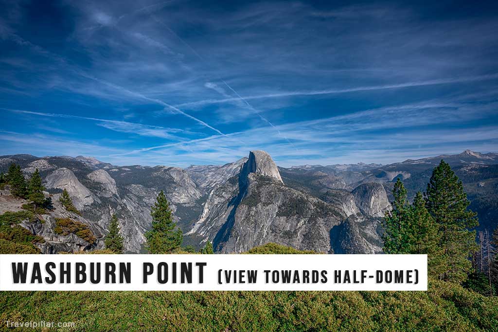
Washburn Point is a scenic overlook that provides stunning views of Yosemite Valley and the surrounding peaks. The point is accessible via a short hike from Glacier Point Road and is a popular spot for photography. Visitors can explore the surrounding area via several hiking trails, including the Panorama Trail, which takes hikers through a scenic forest and offers breathtaking views of Yosemite Valley. Washburn Point is also home to several picnic areas and restrooms.
Google map 4.9/5
Vernall Fall
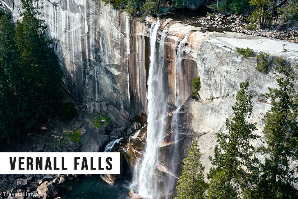
Vernal Fall is a spectacular waterfall that drops 317 feet into the Merced River. The falls are accessible via a short hike from the Happy Isles Trailhead and are a popular destination for hikers and photographers. The most popular trail to Vernal Falls is the Mist Trail, which offers stunning views of the falls and the surrounding forest. The trail is a moderate 3-mile round trip hike, and visitors are advised to wear sturdy shoes and carry plenty of water. In addition to the falls, the area is home to several picnic areas and restrooms.
Google map 4.9/5
Nevada Fall
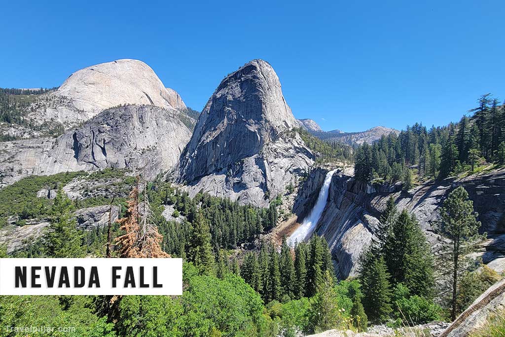
Nevada Fall is a 181-metre (594-foot) waterfall on the Merced River, accessible via the Mist Trail or John Muir Trail. Its distinctive shape and powerful flow make it a notable feature of the park’s high country. The hike offers views of surrounding granite cliffs, including Liberty Cap. Seasonal snowmelt significantly increases the waterfall’s volume in spring, while lower flows occur in late summer and autumn.
Google map 5/5
Mist Trail
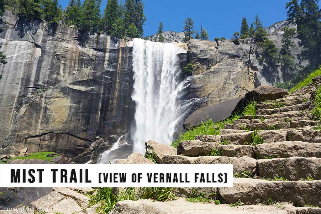
Mist Trail is a popular hiking trail in Yosemite National Park that leads visitors to two of the park’s most impressive waterfalls, Vernal Falls and Nevada Falls. The trail is a moderate 7.2-mile round trip hike and takes hikers through a scenic forest and up a steep series of granite stairs to the top of the falls. The trail is particularly stunning during the spring melt season when the water flow is at its highest, and visitors are advised to wear sturdy shoes and carry plenty of water. In addition to the waterfalls, the area is home to several picnic areas and restrooms.
Google map 4.7/5
Google map (Mist Trailhead) 4.8/5
Tuolumne Meadows
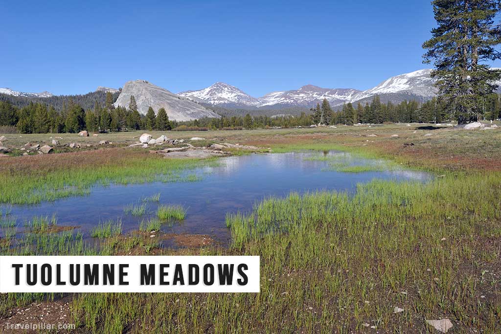
Tuolumne Meadows is a high-elevation meadow located in the eastern part of Yosemite National Park. The meadow is surrounded by towering granite peaks and is home to several hiking trails, picnic areas, and campgrounds. Visitors can explore the area via several hiking trails, including the John Muir Trail and the Pacific Crest Trail, which take hikers through a scenic landscape of meadows, lakes, and forests. The meadow is also home to several backcountry campsites, and visitors are advised to obtain a wilderness permit before camping in the area.
Views towards Lembert Dome
Google map 4.7/5
Cathedral Lakes

Cathedral Lakes are two alpine lakes located in Yosemite National Park’s high country. The lakes are surrounded by towering granite peaks and are accessible via a 7.5-mile round trip hike from the Tuolumne Meadows area. The trail takes hikers through a scenic landscape of meadows, forests, and alpine lakes and offers stunning views of Cathedral Peak and the surrounding peaks. The lakes are a popular destination for fishing, swimming, and camping, and visitors are advised to obtain a wilderness permit before camping in the area.
Google map (Upper Cathedral Lake)
Horsetail Fall

Horsetail Fall is a seasonal waterfall that is located on the east face of El Capitan. The falls are best known for their stunning appearance during the winter months when the setting sun illuminates the falls, creating the illusion of a fiery waterfall. The best time to view Horsetail Fall is during the last two weeks of February, and visitors are advised to arrive early in the afternoon to secure a viewing spot. The falls are accessible via a short hike from the El Capitan Picnic Area.
Google map 4.8/5
Mariposa Grove
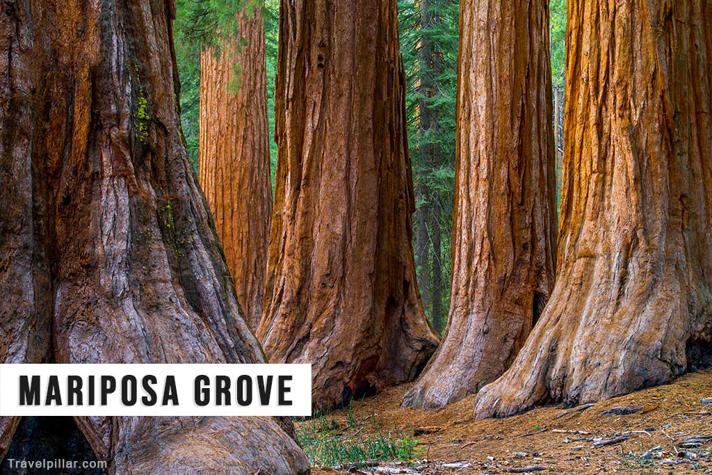
Mariposa Grove is a grove of giant sequoia trees located in Yosemite National Park’s southern area. The grove is home to over 500 mature trees, including the Grizzly Giant, which is over 2,700 years old. Visitors can explore the grove via several hiking trails, including the Mariposa Grove Trail, which takes hikers through a scenic forest of giant sequoias. The grove is also home to several picnic areas and restrooms, and visitors can access the area via a shuttle bus from the park’s south entrance.
Google map 4.7/5